|
The History of Granville,
Licking Co., Ohio
Written by Rev. Henry Bushnell, A. M.
Published by a Company Formed for the Purpose
COLUMBUS, O.
Press of Hann & Adair
1889
CHAPTER II.
Ohio in 1805
pg.15
The passing century dawned to find the westward march of
civilization rapidly breaking at different points across
the Ohio River, into the great undeveloped region
between the river and the lakes, and gaining a foothold
among the valleys never more to be dislodged.
The little spot that concerns us now, according to
Hon. Isaac Smucker, has been "under the control of a
number of foreign powers" and " integral portion of at
least two different States (Virginia and Ohio), and one
Territory (North-West), and six counties (Botetourt,
Illinois, Washington, Ross, Fairfield and Licking)."
Spain early claimed all the land drained by the
Mississippi and its tributaries.
France also claimed the valley of the Ohio and
exercised some jurisdiction over it until the peace of
1763.
England then "became the owner by treaty and exercised
authority over it until 1784."
At the close of the Revolutionary War it passed to the
jurisdiction of the United States.
By the various patents given by England to her colonies
with ill-defined boundaries and indistinct knowledge of
the territories ceded, conflicting claims arose among
the States for possession of this region. As it
had come into the possession of the United States at the
price of treasure and blood expended by all the
colonies, the rest also felt that they had equal claim
to it and equal right of jurisdiction over it. In
1784, or soon after, the States of Massachusetts,
Connecticut, New York, Pennsylvania and Virginia,
severally relinquished these original claims in favor of
the general government.
Virginia, in 1769, while claiming title, erected the
County of Botetourt, whose eastern boundary was
somewhere east of the Ohio, and the western was the
Mississippi River.
Again, in 1778, all west of the Ohio River was set off
and called the County of Illinois.
After the establishing of the Territory of the
Northwest by Congress in 1787, Washington County was
erected, lying between the Ohio and Scioto Rivers, and
running north to Lake Erie. |
In 1798, Ross County was proclaimed, taking in the Ross
County of to-day and all north of it to the Lake.
In 1800, Fairfield, in like manner, took the northern
part of Ross.
In 1808, Licking County was proclaimed with its present
boundaries.
When Granville Township was organized, in 1807, its
bounds upon the north and west extended much further
than at present.
The recognition by Congress of Ohio as a State was on
Feb. 19, 1803. The seat of government until 1810
was Chillicothe. Then for two years it was
transferred to Zanesville, after which it reverted to
Chillicothe until 1816, at which time Columbus became
the capital.
Previous to 1803 there were nine counties: Washington,
erected in 1788; Hamilton, 1790; Adams and Jefferson,
1797; Ross, 1798; Trumbull (all Western Reserve),
Clermont and Fairfield, 1800, and Belmont, 1801.
In 1803, eight more were erected: Butler,
Montgomery, Greene, Warren, Franklin, Scioto, Gallia and
Columbiana. Muskingum was erected in 1804, and
Geauga, Athens, Highland and Champaign in 1805. So
that when the Granville colony took possession of their
homes in 1805, there were twenty-two counties in the
State.
The most powerful of the tribes of Indians occupying,
in early times, the lands of the present State of Ohio,
was probably the Shawnees, or Shawanoese. They
roamed the valley of the Scioto, and as far west as the
Miami and east to the Muskingum, having villages here
and there; and moving northward as settlements were made
along the Ohio.
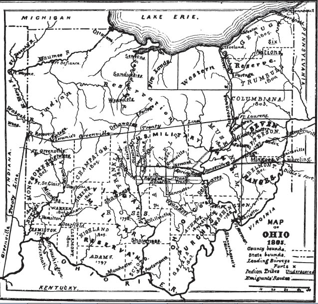
The Wyandots, another powerful tribe occupied the
Hocking Valley, also moving northward to the valley of
the Sandusky. The Delawares were found in the
Muskingum Valley, and the Mingoes (a fragment of the
Senecas, who were of the Six Nations) west of Wheeling.
These tribes moved north-westward; the Delawares to the
headwaters of the Sandusky, and the Mingoes to the mouth
of the same river, on the east side, where they were
called Senecas. The Miamis were in the lower
valley of the Miami, and the Twigtwees near its
headwaters. Remnants of the Six Nations, other
than the Senecas or Mingoes, lived east of the Cuyahoga
River. The "Miamis of the Lake," or Maumees,
probably occupied the valley of that stream, and a small
band of the Ottawas were near its mouth. The
Moravian Indians migrated from Pennsylvania in 1772,
with their missionaries, settling in the valley of the
Tuscarawas, building their villages - Gnadenhutten,
Salem and Schoenbrun - and living quietly by the arts of
peace until massacred in cold blood. The
Chippeways, Kickapoos, Potawatamies, Saginas, and others
are mentioned here and there, but not with prominence,
nor can they be located.
Indian troubles operated as a check to immigration from
the first, until the decided victory of General Wayne,
in 1794, established the "Greenville Treaty Line,"
giving undisputed possession of all the lands south and
east of that line to the United States. The Indian
reservation was bounded by the Cuyahoga River, from its
mouth to the portage, near where Akron now
stands; across by that portage to the Tuscarawas River;
by that stream down to Fort Laurens (a point in the
northern boundary of the present County of Tuscarawas);
thence by a line of survey running a little south of
west, and nearly across the State, to a trading station
on the Miami, marking the portage between the Miami and
St. Marys Rivers, called Loramie's Station; thence north
of west of Fort Recovery, on the head waters of the
Wabash, and near the present State boundary, and thence
west of south to a point opposite the mouth of the
Kentucky River.
In the spring of 1788, "The New England Company" made
the first permanent settlement north of the Ohio, at
Marietta. From this point the settlements reached
out among the hills and up the valleys, until, in 1805,
they had reached the head-waters of the Muskingum, there
to meet similar advancing currents setting in from the
east, the south and the southwest.
In 1788, the settlements at the mouth of the Little
Miami were commenced, and from there, as rapidly, they
spread northward in widening radii, until in 1805, all
that part south of the middle of the State was dotted
with settlements.
In 1790, the Ohio was crossed at Wheeling, and thence
the wave began to roll westward.
In 1805, the prominent points, the choicest localities,
were occupied over half the State, that portion lying
south and east of the middle portion. But the land
was not by any means subdued. It was simply marked
here and there by the outposts of civilization, while
much of it was still an unoccupied wilderness. The
Indians were restricted to their reservation already
described, except as roving squads of them put in an
occasional appearance, or where a few of them were
tolerated in clinging to the homes of their fathers.
Thus it was when the attention of the Granville
emigrants was directed thither. |
|
