|
FLUCTUATIONS IN THE LEVEL OF LAKE ERIE..
----------
[Pg. 479]
When the early emigrants arrived at Buffalo
creek they were at the end of roads. From Canandaigua to lake
Erie, there was only a summer trail for horses, along which sleighs
and sleds could he moved, on the snow in winter. West of
Buffalo there was nothing resembling a road, except an ancient trail
of the savages, not much used by them, except in their warlike
expeditions. Fortunately at the beginning of this century, the
lake was low, causing a beach of clean sand at the margin of the
water. Some of the streams were difficult to ford, but many of
them were so much choked with sand, at their mouths, that teams
could cross. Not far outside of the shore line there is
deposited a changeable sand bar, which forms at the debouche of all
streams, where the force of the current is lost in the still water.
In the transparent waters of our northern lakes this
bank is easily found. The emigrants thus made a passage of the
streams by leaving the land, and
[Pg. 480]
THE SPRING RISE.
driving their teams, apparently into the lake. If the water
was rough, the waves breaking over the beach, they made a
comfortable camp, above the bluffs in the woods near the shore, and
waited patiently for better weather.
A few years afterwards, they were surprised to see this
natural road submerged, by the waters of the lake. This
alternate appearance and disappearance, of the lake beach, has been
a standing mystery to the pioneers and their descendants. It
is a change due to the most simple and natural causes. The
lakes are large ponds or reservoirs, through which the waters of
many united rivers flow to the ocean. All rivers are affected
by the seasons, but it is more noticeable in large ones like the
Mississippi, the Ganges and the Amazon. A year or two of
drought in the country about their main branches, always produces
low water.
When other meteorological conditions occur, and one or
more rainy seasons follow each other, the rivers are high. The
Straits connecting our northern lakes, are short rivers, not having
capacity enough to discharge the surplus waters at once. This
chain of lakes and their connecting outlets may be regarded as one
great river, from tide water at Quebec, to the sources of the St.
Louis river, in Minnesota. Like all large rivers, there is a
spring rise and a winter fall; except in lake Superior, where the
rise occurs in August or September.
[Pg. 481]
SUDDEN OSCILLATIONS.
This annual rise, occurs in June or July,
about the time of the annual flood of the Missouri and the
Mississippi rivers. It is much less in quantity, being only
from twelve to sixteen inches; owing to the expansions, which act as
reservoirs that must be filled; and which when full, require some
months for their discharge. In the fall the surfaces of the
lakes decline, simultaneously, as they rose. A smaller supply
of rain, and increased evaporation, together with a continual
discharge towards the ocean, disposes of the surplus water of the
spring rains. When winter sets in, the supply from the streams
is diminished by frost, and the lowest stage is reached in February
or March.
These results have been obtained by long continued
measurements, of the changes of level on all the lakes, during the
past fifty years.
The annual rise and fall, is only one of the
fluctuations, to which the lakes are subject. There is a
sudden flux and reflux, which is completed in a few seconds, or few
minutes; sometimes due to distant storms, but more often cannot be
traced to a visible cause. Those oscillations are not yet
explained. They occur on all the lakes, and upon other bodies
of water; causing a rush into the mouths of the rivers, generally of
a few inches in height, but some times of several feet. They
have the form of a low undulation coming in from the offing,
parallel with the shore. I have known them to continue many
[Pg. 482]
SECULAR FLUCTUATIONS.
hours, and even days, with unbroken regularity, the interval from
flood to flood, varying from five to eight minutes. Besides
the annual and the sudden fluctuations, there is another which is
more important, and which is called, the "Secular fluctuation."
It occupies a cycle of years, which is not equal in duration.
For a series of years the water is observed to settle away at the
end of the annual decline, lower than it was the previous year at
the same time.
Then it is seen to be higher and higher every year,
till it reaches the maximum height. Reckoning from the highest
annual rise, to the lowest, as at present known; the difference is
six feet nine inches; a change which has an important influence,
upon all harbors and docks. The lowest known stage of water
occurred in February, 1819. From that date, there was a
regular rise until June, 1838, when it flooded warehouses in this
city, to the depth of one foot. At the mouth of
Conneaut creek, the people were
obliged to use boats, in order to pass along the streets, from house
to house.
The remarkable rise of June, 1838, attracted the
attention of every resident, on the shores of lake Erie. In
the other lakes there was a conspicuous elevation about the same
time. The members of the geological surveys of Ohio and
Michigan, made observations upon this flood in the lakes, and
procured what information it was possible to find, in reference to
previous years.
[Pg. 483]
HISTORY OF THE OBSERVATIONS.
Since the settlement of Detroit, in 1701,
it is probable there had been no water as high as that of 1838.
Timber which had grown to maturity on low lands, having an age of
from one to two hundred years, was killed by this flood. From
1788 to 1790, lake Erie is reported to have been very high.
The old French inhabitants affirm, that a road which had long before
been in use on the Detroit river, was rendered useless by high water
in 1802, which agrees with the statements of early settlers in Ohio.
In 1814, and from thence to 1820, Col. HENRY
WHITING, of the U. S. army, made measurements, upon the surface
fluctuations in Detroit river, which disclosed the lowest known
state of the water to be in February, 1819. In more recent
times some of the United States officers, connected with the
construction of harbors on the lakes, kept water registers, some of
them daily or three times a day. Of these were Capt.
MACOMB, (now Colonel,) Lieut. JUDSON, Col. J.
B. STOCKTON, and Lieut. Col. KEARNY. The head of
the Topographical Bureau at Washington, Col. ABERT,
refused all aid and countenance, to these observations, although
they showed a change of level, which rendered their reported
soundings to be erroneous by several feet; for want of a fixed or
mean plane of reference. It was not until Capt. (now
General) MEADE took charge of the lake survey, that regular
daily water registers, were officially kept on the lakes.
Prior to this time, many persons at different places
[Pg. 484]
LIST OF OBSERVERS.
on lake Michigan, lake Erie, and lake Ontario, had had established
points of reference, made frequent measurements, and kept a register
of the same. Among these are JOHN LOTHROP, civil
engineer, Buffalo, N. Y., I. A. LAPHAM, Milwaukee, GEORGE
C. DAVIES, GEORGE TIEBOUT, and I. N. PILLSBURY, at
Cleveland, Dr. DOUGLASS HOUGHTON, A. E. HATHAN, and JACOB
HOUGHTON, Detroit, EDWARD GIDDINGS, Niagara, T. P.
SPENCER, Rochester, and M. P. HATCH, Oswego.
From these sources and from my own observations, in all
numbering some thousands, I have constructed a table of elevations,
going back as far as there is any reliable information. The
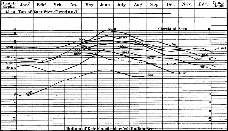
diagram which is here presented, expresses for lake Erie, in a
condensed form addressed to the eye, such of these recorded
measurements as were made once a day or oftener, and were continued
long enough to cover three or more consecutive months. They
are all referred to a common zero, which is the Mitre sill, or
bottom, of the enlarged Erie canal.
The curves are determined by an average of the
observations for each month, expressed in feet and decimals; thus
fixing a point in the middle of the column of months. Through
each of these points a curve is drawn, representing a year or part
of a year. Where there are blanks in the readings, the surves
are continued by dotted lines which are conjectural. This
diagram is on a vertical scale of four feet to
DIAGRAM
showing by curves the mean monthly elevation of the water in LAKE
ERIE so for as determined by daily measurements embracing all the
records prior to 1853, reduced to the depth of water on the mitre
sill at Buffalo, N. Y.
[Pg. 485]
DIAGRAM EXPLAINED.
the inch, a quarter of an inch representing one foot, which is
divided by finer lines, into fifths or two-tenths of a foot.
Each place where registers were kept, had a zero, or point of
reference of its own, but these are reduced by means of consecutive
readings to the one at Buffalo, as the most permanent. At
Cleveland, we used the high water line of June, 1838, counting
downwards. Several marks were made on the piers adn warehouses
at that time, all of which have disappeared, except one, on the wing
wall of the canal lock, at the river. The plane of reference
however, has been preserved by adopting it as the city zero, for
engineering work, and multiplying bench marks in different parts of
the town. Capt. B. STANNARD has kept the registers
here, for the lake survey since 1854.
A similar diagram might now be made for the years;
taking the mean height of each period of twelve months as the
ordinate, instead of one month, and thus show at a glance, the
secular fluctuations. For the three best determined years, in
my tables, the difference is as follows, counting downwards; the
lake being on a declining stage of the water.
| 1839, below 1838, . . . . . . . |
1.25 feet |
| 1840, below 1839, . . . . . . . |
1.25 feet |
| 1841, below 1840, . . . . . . . |
1.65 feet |
| Total decline in three years |
4.15 feet |
[Pg. 486]
ANNUAL FLUCTUATIONS.
An examination of the curves at once
demonstrates what I have already stated; that there is an annual
spring rise, and a winter fall in the surface of the lakes, like
that of our large rivers. This annual difference between the
highest and lowest months, is not precisely the same at all places.
At Cleveland, the average of 16 years is 1 ft. 3 in.
At Detroit, "
" " "
" " 1 " 2½
"
At Buffalo, "
" " "
" " 0 " 10½ "
Average of
these three stations,
1 ft. 1½ in.
These observations dispel the popular
belief, derived from the Indians; that the lakes rise seven years
and decline seven years. This could not be the case, unless
the seasons should repeat themselves in every particular, in that
period. In these tables there is no case of a change at seven,
or at fourteen years.
From 1819 to 1838, there was a continual rise; a period
of nineteen years. From 1838 to 1841, a decline; in 1841 a
slight rise, and from 1842 to 1851, eight years, a regular decline.
In 1853-54 there was a high stage; in the latter year for a short
period fully up to the line of 1838. Since 1853, we can rely
upon the water registers of the lake survey, for which an effort is
now being made before Congress to have them published. By
these it was discovered, after many thousands of observations on
lake Michigan, by Lieut. Col. GRAHAM and Prof.
[Pg. 487]
THE LUNAR TIDE.
LAPHAN, that there is a slight lunar tide on the lakes.
It is too small for direct cognizance, being for ordinary tide at
Chicago, only 153/1000 of a foot or 1 inch 84/100, for the spring
tides 454/1000 or 3 inches 48/100.
END OF CHAPTER
- END OF BOOK - <
CLICK HERE TO RETURN TO
TABLE OF CONTENTS > |
